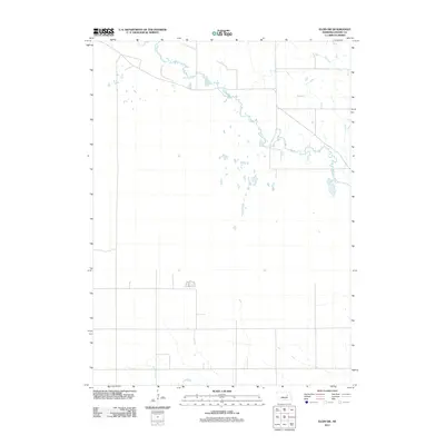
2011 Map of Elgin SW
USGS Topo · Published 2011About this map
Beaver Creek meanders through the northern and eastern reaches of this Boone County landscape, carving a detailed hydrologic pattern across the agricultural plains of Nebraska. The terrain is defined by the subtle shift from the riparian corridors of the north to the more open drainage patterns around Plum Creek in the southwest corner. Published by the U.S. Geological Survey in 2011, this survey documents the rural road network and section lines that form the backbone of the region's land use. The map offers a clear view of the prairie's topography at a 1:24,000 scale, capturing the interplay between the natural watercourses and the human-imposed grid of local transport routes.
Find a feature on this map
2 named features on this map. Tap any name to fly to it.
Don’t see what you’re looking for? This feature index may not catch every label — zoom into the map to look around manually.
Map Details
Editions of this 2011 Elgin SW Map
This is the sole edition of this map. No revisions or reprints were ever made.
Other maps of this area

1954 · Spalding
USGS Topo · 1:24,000

1954 · Akron
USGS Topo · 1:24,000

1954 · Albion West
USGS Topo · 1:24,000

1955 · Broken Bow
USGS Topo · 1:250,000

1956 · Broken Bow
USGS Topo · 1:250,000

1960 · Spalding 2 NE
USGS Topo · 1:24,000

1960 · Spalding 2 SE
USGS Topo · 1:24,000

1963 · Petersburg
USGS Topo · 1:24,000

1963 · Elgin NW
USGS Topo · 1:24,000
1963 · Elgin SW
USGS Topo · 1:24,000