
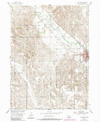
1954 Map of Albion West
USGS Topo · Published 1956About this map
The county seat of Albion anchors the eastern edge of this mid-century survey, revealing a well-established agricultural community organized by several rural townships including Ashland, Midland, Manchester, Roselma, and Boone. The landscape is defined by the winding course of Beaver Creek and the diagonal path of the Chicago and North Western railroad. Educational infrastructure is particularly prominent, with a network of country schools such as Maple Hill Sch, Beaver Valley Sch, and numbered districts like School No 2 and School No 81 serving the surrounding farms.
Find a feature on this map
25 named features on this map. Tap any name to fly to it.
Don’t see what you’re looking for? This feature index may not catch every label — zoom into the map to look around manually.
Map Details
Editions of this 1954 Albion West Map
2 editions found
Other maps of this area

1954 · Cedar Rapids
USGS Topo · 1:24,000

1954 · Akron
USGS Topo · 1:24,000

1954 · Cedar Rapids SE
USGS Topo · 1:24,000

1955 · Broken Bow
USGS Topo · 1:250,000

1955 · Fremont
USGS Topo · 1:250,000

1956 · Broken Bow
USGS Topo · 1:250,000

1957 · Fremont
USGS Topo · 1:250,000

1958 · Fremont
USGS Topo · 1:250,000

1958 · Albion East
USGS Topo · 1:24,000
1958 · St. Edward SW
USGS Topo · 1:24,000