
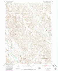
1954 Map of Cedar Rapids SE
USGS Topo · Published 1956About this map
Cedar River and Plum Creek define the drainage and settlement patterns across this corner of Nebraska, where the terrain transitions toward the Missouri River Basin. The map reveals a post-war rural landscape organized around the Old Indian Boundary, which cuts across the southern section near the Boone and Nance County line. This era captures a high density of rural community infrastructure, including numerous educational sites such as Belle Valley Sch, Ash Hollow Sch, and Midvale Sch.
Find a feature on this map
18 named features on this map. Tap any name to fly to it.
Don’t see what you’re looking for? This feature index may not catch every label — zoom into the map to look around manually.
Map Details
Editions of this 1954 Cedar Rapids SE Map
2 editions found
Other maps of this area

1896 · Stromsburg
USGS Topo · 1:125,000

1899 · St. Paul
USGS Topo · 1:125,000

1954 · Cedar Rapids
USGS Topo · 1:24,000

1954 · Akron
USGS Topo · 1:24,000

1954 · Albion West
USGS Topo · 1:24,000

1954 · Belgrade
USGS Topo · 1:24,000

1954 · Belgrade NW
USGS Topo · 1:24,000

1955 · Broken Bow
USGS Topo · 1:250,000

1955 · Fremont
USGS Topo · 1:250,000

1956 · Broken Bow
USGS Topo · 1:250,000