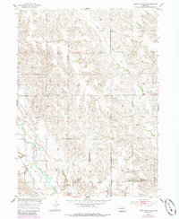
1954 Map of Cedar Rapids SE
USGS Topo · Published 1985About this map
The Old Indian Boundary bisects the southern reaches of this landscape, marking a significant historical line across Boone and Nance counties. This survey, updated in the mid-1980s, highlights the drainage patterns of Plum Creek and the meandering Cedar River, which dominates the southwest corner of the quadrangle. The Union Pacific railroad corridor follows the river valley, reflecting the critical infrastructure that supported the development of the Missouri River Basin. The terrain is characterized by intricate contour lines defining the upland ridges and draws, with a few isolated landmarks such as a Windmill and the small settlement of Cedar providing points of reference for local history and genealogy researchers tracking the rural development of this Nebraska region during the mid-20th century.
Find a feature on this map
7 named features on this map. Tap any name to fly to it.
Don’t see what you’re looking for? This feature index may not catch every label — zoom into the map to look around manually.
Map Details
Editions of this 1954 Cedar Rapids SE Map
2 editions found
Other maps of this area

1896 · Stromsburg
USGS Topo · 1:125,000

1899 · St. Paul
USGS Topo · 1:125,000

1954 · Cedar Rapids
USGS Topo · 1:24,000

1954 · Akron
USGS Topo · 1:24,000

1954 · Albion West
USGS Topo · 1:24,000

1954 · Belgrade
USGS Topo · 1:24,000

1954 · Belgrade NW
USGS Topo · 1:24,000

1954 · Cedar Rapids SE
USGS Topo · 1:24,000

1955 · Broken Bow
USGS Topo · 1:250,000

1955 · Fremont
USGS Topo · 1:250,000