
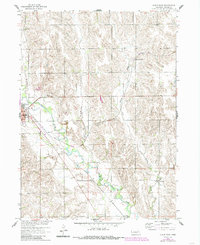
1958 Map of Albion East
USGS Topo · Published 1960About this map
The fertile valley of Beaver Creek serves as the primary corridor for settlement and transit in this late-1950s Nebraska landscape. Following the water's path, the Chicago North Western and Union Pacific railroad links the larger community of Albion to the smaller siding of Vothees and the town of Boone in the southeast. This survey captures a highly organized agrarian infrastructure, defined by a regular grid of section roads and townships including Manchester, Weitzel, and O'Neill.
Find a feature on this map
19 named features on this map. Tap any name to fly to it.
Don’t see what you’re looking for? This feature index may not catch every label — zoom into the map to look around manually.
Map Details
Editions of this 1958 Albion East Map
2 editions found
Other maps of this area

1954 · Albion West
USGS Topo · 1:24,000

1954 · Cedar Rapids SE
USGS Topo · 1:24,000

1955 · Broken Bow
USGS Topo · 1:250,000

1955 · Fremont
USGS Topo · 1:250,000

1956 · Broken Bow
USGS Topo · 1:250,000

1957 · Fremont
USGS Topo · 1:250,000

1958 · Fremont
USGS Topo · 1:250,000

1958 · St. Edward
USGS Topo · 1:24,000
1958 · St. Edward SW
USGS Topo · 1:24,000

1963 · Petersburg
USGS Topo · 1:24,000