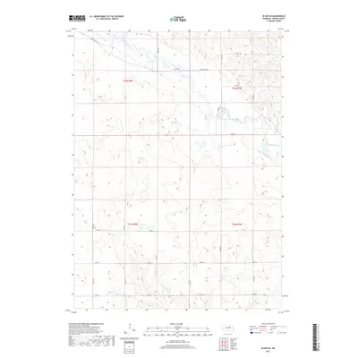
2017 Map of Elgin SW
USGS Topo · Published 2017About this map
Beaver Creek and Plum Cr define the hydrological landscape of this Boone County region, cutting through a grid of rural agricultural land. The map illustrates the structured Public Land Survey System (PLSS) layout, showing the intersections of t22n r8w, t22n r7w, t21n r8w, and t21n r7w. This geometric organization is reflected in the precise road network, where routes like 150th Ave and 210th St follow section lines. Beaver Valley Rd provides the primary diagonal corridor across the northern sections, tracing the natural path of the creek valley. This 2017 survey serves as a clear record of modern Nebraska farmstead distribution and land management, where the elevation contours reveal subtle drainage patterns and wetlands that continue to shape the local agricultural economy.
Find a feature on this map
21 named features on this map. Tap any name to fly to it.
Don’t see what you’re looking for? This feature index may not catch every label — zoom into the map to look around manually.
Map Details
Editions of this 2017 Elgin SW Map
This is the sole edition of this map. No revisions or reprints were ever made.
Other maps of this area

1954 · Spalding
USGS Topo · 1:24,000

1954 · Akron
USGS Topo · 1:24,000

1954 · Albion West
USGS Topo · 1:24,000

1955 · Broken Bow
USGS Topo · 1:250,000

1956 · Broken Bow
USGS Topo · 1:250,000

1960 · Spalding 2 NE
USGS Topo · 1:24,000

1960 · Spalding 2 SE
USGS Topo · 1:24,000

1963 · Petersburg
USGS Topo · 1:24,000

1963 · Elgin NW
USGS Topo · 1:24,000
1963 · Elgin SW
USGS Topo · 1:24,000