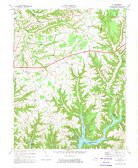
1973 Map of Eli
USGS Topo · Published 1974About this map
Lake Cumberland dominates the southern landscape of this 1970s survey, showing the controlled inundation of the Cumberland River valley that reshaped the geography of Russell and Pulaski counties. The map captures the complex shoreline at the mouths of Alligator Creek and Wolf creek, including the established Boat Ramps and a Trailer Park that signify the area's mid-century recreational shift. To the north, the upland ridges of Bethany Ridge and Roytown Ridge remain defined by traditional agricultural settlements and rural infrastructure.
Find a feature on this map
99 named features on this map. Tap any name to fly to it.
Don’t see what you’re looking for? This feature index may not catch every label — zoom into the map to look around manually.
Map Details
Editions of this 1973 Eli Map
This is the sole edition of this map. No revisions or reprints were ever made.
Other maps of this area

1911 · Monticello
USGS Topo · 1:62,500

1914 · Monticello
USGS Topo · 1:62,500

1953 · Phil
USGS Topo · 1:24,000

1953 · Mintonville
USGS Topo · 1:24,000

1953 · Mill Springs
USGS Topo · 1:24,000

1953 · Jamestown
USGS Topo · 1:24,000

1953 · Dunnville
USGS Topo · 1:24,000

1954 · Jabez
USGS Topo · 1:24,000

1954 · Russell Springs
USGS Topo · 1:24,000

1954 · Eli
USGS Topo · 1:24,000