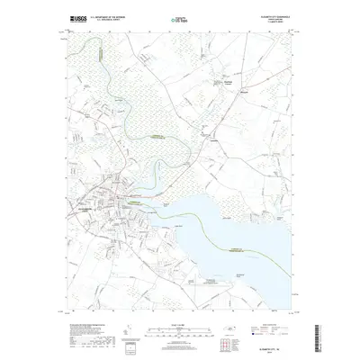
2019 Map of Elizabeth City
USGS Topo · Published 2019About this map
The Pasquotank River serves as the central artery for this coastal landscape, dividing Pasquotank and Camden Counties as it flows toward the Albemarle Sound. The urban heart of Elizabeth City dominates the western bank, where dense street grids meet the Intracoastal Waterway at Cottage Point. On the eastern shore, the transition to rural Camden County is marked by small settlements like Camden and Belcross, surrounded by an extensive network of wetlands including the Black Swamp. This geography highlights the region's historic dependence on water for both industry and transport, with numerous points like Hospital Point and Anson Point jutting into the broad river. Genealogists will find a wealth of local history in the numerous family burial sites and memorial grounds, such as the Hollowell Family Plot, Smithson Family Cem, and New Sawyers Creek Missionary Baptist Cem, which are scattered throughout the agricultural and marshy periphery.
Find a feature on this map
178 named features on this map. Tap any name to fly to it.
Don’t see what you’re looking for? This feature index may not catch every label — zoom into the map to look around manually.
Map Details
Editions of this 2019 Elizabeth City Map
This is the sole edition of this map. No revisions or reprints were ever made.
Other maps of this area

1906 · Hertford
USGS Topo · 1:62,500

1940 · Hertford
USGS Topo · 1:62,500

1940 · Wade Point
USGS Topo · 1:62,500

1940 · South Mills
USGS Topo · 1:62,500

1943 · Wade Point
USGS Topo · 1:62,500

1948 · Wade Point
USGS Topo · 1:62,500

1948 · Elizabeth City
USGS Topo · 1:62,500

1952 · South Mills
USGS Topo · 1:62,500

1953 · Norfolk
USGS Topo · 1:250,000

1982 · Nixonton
USGS Topo · 1:24,000