
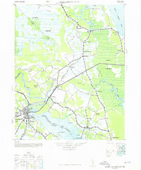
1948 Map of Elizabeth City
USGS Topo · Published 1948About this map
The Norfolk Southern Railroad defines the terrestrial movement of this coastal landscape, cutting a diagonal path through Camden and Currituck counties to connect settlements like Shawboro and Belcross. This mid-century survey illustrates an environment deeply intertwined with water and drainage, characterized by the vast reaches of the Dismal Swamp and Great Swamp, as well as engineered waterways like the Roland Creek Canal and Run Swamp Canal. While Elizabeth City anchors the southwestern corner, the map reveals a network of rural crossroads and landings, including Lambs Corner, Spences Corner, and the riverside community of Shiloh. Industrial and commercial footprints are visible at the Lumber Mill near Indian Town and the waterfront at Texaco Beach. The presence of numerous small settlements such as Sligo, Snowden, and Maple reflects a dispersed agricultural and timber-based economy established well before the modern expansion of the region.
Find a feature on this map
42 named features on this map. Tap any name to fly to it.
Don’t see what you’re looking for? This feature index may not catch every label — zoom into the map to look around manually.
Map Details
Editions of this 1948 Elizabeth City Map
2 editions found
Other maps of this area

1893 · Virginia Beach
USGS Topo · 1:125,000

1906 · Hertford
USGS Topo · 1:62,500

1916 · Back Bay
USGS Topo · 1:62,500

1939 · Moyock
USGS Topo · 1:62,500

1940 · Barco
USGS Topo · 1:62,500

1940 · Hertford
USGS Topo · 1:62,500

1940 · Powells Point
USGS Topo · 1:62,500

1940 · Lake Drummond
USGS Topo · 1:62,500

1940 · Wade Point
USGS Topo · 1:62,500

1940 · South Mills
USGS Topo · 1:62,500