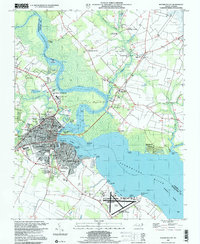
1997 Map of Elizabeth City
USGS Topo · Published 2000About this map
Elizabeth City sits at a strategic bend of the Pasquotank River, serving as a central hub for commerce and education in northeastern North Carolina. The map reveals a landscape defined by its relation to the water, from the Intracostal Waterway following the river's main channel to the numerous tidal flats and points like Hospital Point and Brickhouse Point. Educational institutions are prominent, including Elizabeth City State University and the College of The Albemarle, alongside smaller community landmarks like Sawyers Creek Ch and Camden Middle Sch. To the southeast, the U S Coast Guard Air Base and Elizabeth City Municipal Airport occupy a significant footprint along the shores of Davis Bay. This survey captures the transition from the dense urban grid of the city center to the outlying agricultural and marshland reaches of Pasquotank and Camden counties.
Find a feature on this map
72 named features on this map. Tap any name to fly to it.
Don’t see what you’re looking for? This feature index may not catch every label — zoom into the map to look around manually.
Map Details
Editions of this 1997 Elizabeth City Map
This is the sole edition of this map. No revisions or reprints were ever made.
Other maps of this area

1906 · Hertford
USGS Topo · 1:62,500

1940 · Hertford
USGS Topo · 1:62,500

1940 · Wade Point
USGS Topo · 1:62,500

1940 · South Mills
USGS Topo · 1:62,500

1943 · Wade Point
USGS Topo · 1:62,500

1948 · Wade Point
USGS Topo · 1:62,500

1948 · Elizabeth City
USGS Topo · 1:62,500

1952 · South Mills
USGS Topo · 1:62,500

1953 · Norfolk
USGS Topo · 1:250,000

1982 · Nixonton
USGS Topo · 1:24,000