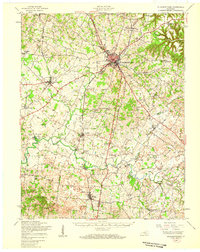
1949 Map of Elizabethtown
USGS Topo · Published 1959About this map
Elizabethtown serves as the central hub of this mid-century survey, where the Louisville And Nashville Railroad and Illinois Central Railroad intersect. The landscape is a network of small agricultural settlements and crossroads communities, such as Cecilia, Glendale, and Sonora. The presence of numerous parochial and rural institutions, including the Bethlehem Academy and the Childrens Home, reflects a deeply established social fabric in Hardin and LaRue Counties. The drainage of the Nolin River and its tributaries, including Billy Creek and Valley Creek, dictates the placement of early industry like Eagle Mills and Mathers Mill. To the north, the terrain is marked by Tunnel Hill, while the Osborne Quarry signifies local extraction. This map captures the region after the 1940s field checks, showcasing a transition from rail-dependent commerce to an expanding system of local roads and schools like Edin Sch and Crossroads Sch.
Find a feature on this map
72 named features on this map. Tap any name to fly to it.
Don’t see what you’re looking for? This feature index may not catch every label — zoom into the map to look around manually.
Map Details
Editions of this 1949 Elizabethtown Map
This is the sole edition of this map. No revisions or reprints were ever made.
Other maps of this area

1925 · Cub Run
USGS Topo · 1:62,500

1932 · Big Clifty
USGS Topo · 1:62,500

1934 · Munfordville
USGS Topo · 1:48,000

1935 · Elizabethtown
USGS Topo · 1:48,000

1936 · Vine Grove
USGS Topo · 1:62,500

1937 · Munfordville
USGS Topo · 1:62,500

1938 · Elizabethtown
USGS Topo · 1:62,500

1941 · Ekron
USGS Topo · 1:62,500

1943 · Vine Grove
USGS Topo · 1:62,500

1946 · Colesburg
USGS Topo · 1:24,000