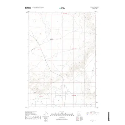
2017 Map of Elk Basin SW
USGS Topo · Published 2017About this map
Polecat Bench dominates the eastern elevation of this 2017 survey, providing a stark topographical contrast to the more level terrain of Ralston Flats to the southwest. The landscape is defined by its drainage and irrigation systems, where the meandering course of Big Sand Coulee and the West Fork Big Sand Coulee carve through the northern sections. This arid Park County environment shows a sophisticated network of water management, evidenced by named canals and laterals such as Lateral H-141 and the Ralston Lateral. These features suggest a region shaped by agricultural necessity, where water is carefully diverted from natural sources like N Alkali Cr to support the surrounding lands. The grid of rural roads, including Little Sand Coulee Rd and various numbered routes, underscores the structured human footprint on this high-plains landscape.
Find a feature on this map
23 named features on this map. Tap any name to fly to it.
Don’t see what you’re looking for? This feature index may not catch every label — zoom into the map to look around manually.
Map Details
Editions of this 2017 Elk Basin SW Map
This is the sole edition of this map. No revisions or reprints were ever made.
Other maps of this area

1949 · Cody
USGS Topo · 1:62,500

1950 · Clark
USGS Topo · 1:62,500

1951 · Cody
USGS Topo · 1:62,500

1955 · Cody
USGS Topo · 1:250,000

1958 · Cody
USGS Topo · 1:250,000

1962 · Cody
USGS Topo · 1:250,000

1966 · Elk Basin SW
USGS Topo · 1:24,000

1966 · Elk Basin
USGS Topo · 1:24,000

1966 · Elk Basin NW
USGS Topo · 1:24,000

1966 · Elk Basin SE
USGS Topo · 1:24,000