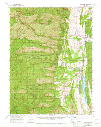
1957 Map of Elk Creek
USGS Topo · Published 1966About this map
Mendocino National Forest dominates the western half of this Glenn County landscape, where deep canyons and high points like Sanhedrin Ridge define the transition to the Sacramento Valley. The 1957 revision captures a rural economy shaped by ranching and timber, evidenced by numerous named homesteads such as Gillaspy Ranch, Rowcroft Ranch, and Garrison Ranch. Cultural landmarks like the Grindstone Rancheria Indian Res and the town of Elk Creek sit along the eastern edge, where the terrain flattens toward the water.
Find a feature on this map
75 named features on this map. Tap any name to fly to it.
Don’t see what you’re looking for? This feature index may not catch every label — zoom into the map to look around manually.
Map Details
Editions of this 1957 Elk Creek Map
2 editions found

Other maps of this area

1919 · Fruto
USGS Topo · 1:62,500

1919 · Elk Creek
USGS Topo · 1:62,500

1922 · Hullville
USGS Topo · 1:62,500

1943 · Lodoga
USGS Topo · 1:62,500

1944 · Fruto
USGS Topo · 1:62,500

1944 · Flournoy
USGS Topo · 1:62,500

1948 · Elk Creek
USGS Topo · 1:62,500

1951 · Lake Pillsbury
USGS Topo · 1:62,500

1951 · Stonyford
USGS Topo · 1:62,500

1952 · Paskenta
USGS Topo · 1:62,500