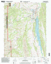
1996 Map of Elk Creek
USGS Topo · Published 2001About this map
Stony Gorge Reservoir dominates the eastern edge of this landscape, its waters held back by the Stony Gorge Dam. The settlement of Elk Creek serves as a local hub just north of the lake, containing a High Sch, a Cemetery, and an USFS Work Center with an adjacent fire station. This area reflects a mix of public forest management and private ranching interests, evidenced by the large expanse of the Mendocino National Forest to the west and the presence of family-named landmarks like Butler Place.
Find a feature on this map
34 named features on this map. Tap any name to fly to it.
Don’t see what you’re looking for? This feature index may not catch every label — zoom into the map to look around manually.
Map Details
Editions of this 1996 Elk Creek Map
This is the sole edition of this map. No revisions or reprints were ever made.
Other maps of this area

1919 · Fruto
USGS Topo · 1:62,500

1919 · Elk Creek
USGS Topo · 1:62,500

1943 · Lodoga
USGS Topo · 1:62,500

1944 · Fruto
USGS Topo · 1:62,500

1948 · Elk Creek
USGS Topo · 1:62,500

1951 · Stonyford
USGS Topo · 1:62,500

1957 · Elk Creek
USGS Topo · 1:62,500

1957 · Ukiah
USGS Topo · 1:250,000
1958 · Fruto
USGS Topo · 1:62,500

1960 · Ukiah
USGS Topo · 1:250,000