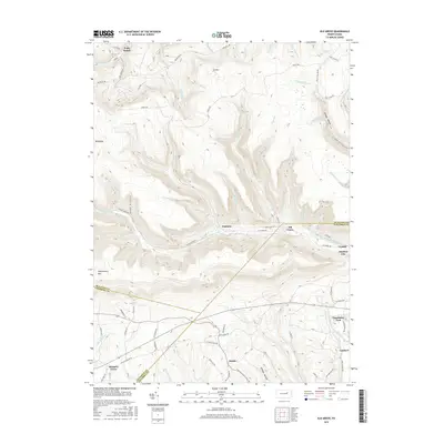
2016 Map of Elk Grove
USGS Topo · Published 2016About this map
West Branch Fishing Creek carves a deep valley through the northern reaches of Columbia and Sullivan Counties, anchoring the small settlements of Elk Grove and Jamison City. This landscape is defined by the high elevations of N Mtn and Huckleberry Mtn, where numerous seasonal runs like Bloody Run and Shingle Mill Run descend toward the valley floor. The settlement pattern follows the narrow corridors of the creeks, with Emmons and Central positioned along the primary water routes. To the south, the terrain levels slightly near the communities of Divide and Laubach, where the headwaters of Little Fishing Cr emerge. The presence of Grassmere Park and various family-named landmarks like Richarts Grove reflects a long history of rural habitation in the Pennsylvania mountains, while the extensive network of forest roads suggests the area's continued importance for timber and watershed management.
Find a feature on this map
77 named features on this map. Tap any name to fly to it.
Don’t see what you’re looking for? This feature index may not catch every label — zoom into the map to look around manually.
Map Details
Editions of this 2016 Elk Grove Map
This is the sole edition of this map. No revisions or reprints were ever made.
Other maps of this area

1894 · Bloomsburg
USGS Topo · 1:62,500

1927 · Eagles Mere
USGS Topo · 1:48,000

1932 · Eagle Mere
USGS Topo · 1:62,500

1934 · Laporte
USGS Topo · 1:62,500

1935 · Hughesville
USGS Topo · 1:62,500

1947 · Stillwater
USGS Topo · 1:24,000

1947 · Benton
USGS Topo · 1:31,680
1953 · Benton
USGS Topo · 1:24,000

1953 · Hughesville
USGS Topo · 1:62,500

1953 · LaPorte
USGS Topo · 1:62,500
Featured Places
- Jackson Township, PA
- Laporte Township, PA
- Pine Township, PA
- Divide, Jackson Township
- Emmons, Davidson Township