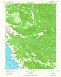
1960 Map of Elk
USGS Topo · Published 1967About this map
Elk sits along the Mendocino coastline, serving as a focal point for this 1960s landscape where steep ridges meet the Pacific. The terrain is defined by a series of prominent parallel ridges, including Albion Ridge, Navarro Ridge, and Greenwood Ridge, which separate the major drainages of the Albion River and Navarro River. Inland, local infrastructure such as the Greenwood School and a rural Airstrip indicate the community's mid-century development. Evidence of the region's timber and transport history is visible in names like Railroad Road and the Burner located along the Navarro. The rugged shore is marked by distinct features such as Devils Basin, Casket Rock, and St Anthonys Point, while the interior preserves natural spaces like Dimmick Memorial Grove State Park along the river's north fork.
Find a feature on this map
66 named features on this map. Tap any name to fly to it.
Don’t see what you’re looking for? This feature index may not catch every label — zoom into the map to look around manually.
Map Details
Editions of this 1960 Elk Map
3 editions found
Other maps of this area

1920 · Glenblair
USGS Topo · 1:62,500

1920 · Fort Bragg
USGS Topo · 1:62,500

1943 · Glenblair
USGS Topo · 1:62,500

1943 · Fort Bragg
USGS Topo · 1:62,500

1943 · Albion
USGS Topo · 1:62,500

1943 · Navarro
USGS Topo · 1:62,500

1944 · Saddle Point
USGS Topo · 1:62,500

1957 · Ukiah
USGS Topo · 1:250,000

1960 · Ukiah
USGS Topo · 1:250,000
1960 · Elk
USGS Topo · 1:24,000