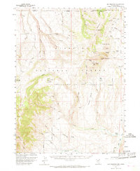
1957 Map of Elk Mountain
USGS Topo · Published 1968About this map
Elk Mountain dominates the high-desert terrain of northern Nevada near the Idaho border, where the headwaters of numerous creeks diverge across the Humboldt National Forest. This 1957 field-checked survey reveals a remote landscape defined by cattle ranching and early administrative outposts, notably the O'Neil Ranger Sta and the O'Neil Ranch situated along the lower draws. The complex topography is punctuated by distinctive geological formations such as White Elephant Butte and Red Elephant Butte, with the drainage network of Salmon Falls Creek carving through the eastern canyons. A sparse network of jeep trails provides the only access through this country, connecting various livestock springs like Bull Camp Spring and Elk Spring. The map documents the intersection of Owyhee, Elko, and Twin Falls counties, illustrating a region where high-altitude ridges like Buckhorn Ridge served as critical landmarks for early surveyors and ranchers.
Find a feature on this map
44 named features on this map. Tap any name to fly to it.
Don’t see what you’re looking for? This feature index may not catch every label — zoom into the map to look around manually.
Map Details
Editions of this 1957 Elk Mountain Map
3 editions found
Other maps of this area

1943 · Jarbidge
USGS Topo · 1:62,500

1945 · Jarbidge
USGS Topo · 1:62,500

1955 · Twin Falls
USGS Topo · 1:250,000

1955 · Wells
USGS Topo · 1:250,000

1957 · Contact
USGS Topo · 1:62,500

1957 · Elk Mountain
USGS Topo · 1:62,500

1958 · Wells
USGS Topo · 1:250,000

1958 · Twin Falls
USGS Topo · 1:250,000

1961 · Wells
USGS Topo · 1:250,000

1968 · Hubbard Basin
USGS Topo · 1:24,000