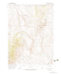
1957 Map of Elk Mountain
USGS Topo · Published 1983About this map
Humboldt National Forest encompasses the majority of this high-elevation landscape, where the state boundaries of Nevada and Idaho meet at the northern edge. The area is defined by a series of prominent peaks and buttes, including White Elephant Butte and Red Elephant Butte, which rise above the surrounding terrain of Buckhorn Ridge. This region reflects a mid-century period of federal land management and seasonal ranching, marked by scattered water sources like Bull Camp Spring and Pockets Spring that were vital for livestock and local wildlife.
Find a feature on this map
46 named features on this map. Tap any name to fly to it.
Don’t see what you’re looking for? This feature index may not catch every label — zoom into the map to look around manually.
Map Details
Editions of this 1957 Elk Mountain Map
3 editions found
Other maps of this area

1943 · Jarbidge
USGS Topo · 1:62,500

1945 · Jarbidge
USGS Topo · 1:62,500

1955 · Twin Falls
USGS Topo · 1:250,000

1955 · Wells
USGS Topo · 1:250,000

1957 · Contact
USGS Topo · 1:62,500

1957 · Elk Mountain
USGS Topo · 1:62,500

1958 · Wells
USGS Topo · 1:250,000

1958 · Twin Falls
USGS Topo · 1:250,000

1961 · Wells
USGS Topo · 1:250,000

1968 · Hubbard Basin
USGS Topo · 1:24,000