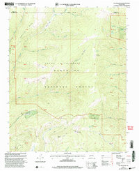
2002 Map of Elk Mountain
USGS Topo · Published 2003About this map
Elk Mountain and Mount Barker dominate this high-altitude landscape in the Pecos River headwaters during the early 2000s. This survey, revised by the Forest Service, documents a transition from the protected Pecos Wilderness to the managed lands of the Santa Fe National Forest. The map captures several distinctive high-country features, including the Electronic Site near the summit of Elk Mountain and a Mine located in the headwaters of Hollinger Canyon.
Find a feature on this map
37 named features on this map. Tap any name to fly to it.
Don’t see what you’re looking for? This feature index may not catch every label — zoom into the map to look around manually.
Map Details
Editions of this 2002 Elk Mountain Map
This is the sole edition of this map. No revisions or reprints were ever made.
Other maps of this area

1889 · Las Vegas
USGS Topo · 1:125,000

1889 · Santa Fe
USGS Topo · 1:125,000

1891 · Las Vegas
USGS Topo · 1:125,000

1893 · Las Vegas
USGS Topo · 1:125,000

1894 · Santa Fe
USGS Topo · 1:125,000

1954 · Santa Fe
USGS Topo · 1:250,000

1958 · Santa Fe
USGS Topo · 1:250,000

1961 · El Porvenir
USGS Topo · 1:24,000

1961 · Honey Boy Ranch
USGS Topo · 1:24,000

1961 · Rosilla Peak
USGS Topo · 1:24,000