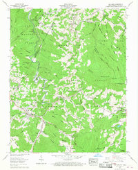
1960 Map of Elk Park
USGS Topo · Published 1968About this map
Cranberry Mines and the presence of a Dismantled RR reflect the industrial heritage of this mountainous border region between North Carolina and Tennessee. The map centers on the high-elevation settlements of Elk Park and Banner Elk, where institutional landmarks like Lees-McRae College and the Grandfather Home for Children are established alongside the Elk River. The terrain is defined by significant peaks such as Beech Mountain and Hump Mountain, with the Appalachian Trail traversing the ridgelines. Family history is well-preserved through numerous rural burial grounds and places of worship, including Cranberry Cem, Harmon Cem, and Arbor Dale Ch. The landscape shows a transition from the Cherokee National Forest in the west to the Pisgah National Forest and Linville areas, punctuated by small communities like Heaton and Whaley.
Find a feature on this map
127 named features on this map. Tap any name to fly to it.
Don’t see what you’re looking for? This feature index may not catch every label — zoom into the map to look around manually.
Map Details
Editions of this 1960 Elk Park Map
3 editions found
Other maps of this area

1891 · Roan Mountain
USGS Topo · 1:125,000

1893 · Cranberry
USGS Topo · 1:125,000

1894 · Roan Mountain
USGS Topo · 1:125,000

1895 · Cranberry
USGS Topo · 1:125,000

1899 · Cranberry
USGS Topo · 1:125,000

1902 · Cranberry
USGS Topo · 1:125,000

1904 · Roan Mountain
USGS Topo · 1:125,000

1934 · Valle Crucis
USGS Topo · 1:24,000

1934 · White Rocks Mtn
USGS Topo · 1:24,000

1934 · Elk Park
USGS Topo · 1:24,000