
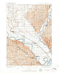
1898 Map of Elk Point
USGS Topo · Published 1960About this map
The Missouri River and its major tributaries, the Vermillion River and Big Sioux River, define the landscape of this tri-state border region before the era of modern channelization. The river culture of the late nineteenth century is clearly visible through active crossings such as Vermilion Ferry, Ionia Ferry, and Ponca Ferry. These transit points supported an economy linked by major rail lines, including the Chicago Milwaukee and St. Paul RR, which connected settlements like Vermillion, Burbank, and Elk Point.
Find a feature on this map
90 named features on this map. Tap any name to fly to it.
Don’t see what you’re looking for? This feature index may not catch every label — zoom into the map to look around manually.
Map Details
Editions of this 1898 Elk Point Map
2 editions found
Other maps of this area

1897 · Canton
USGS Topo · 1:125,000

1898 · Parker
USGS Topo · 1:125,000

1900 · Canton
USGS Topo · 1:125,000

1901 · Elk Point
USGS Topo · 1:125,000

1907 · Elk Point
USGS Topo · 1:125,000

1955 · Sioux City
USGS Topo · 1:250,000

1955 · Sioux Falls
USGS Topo · 1:250,000

1958 · Sioux City
USGS Topo · 1:250,000

1958 · Sioux Falls
USGS Topo · 1:250,000

1959 · Sioux City
USGS Topo · 1:250,000