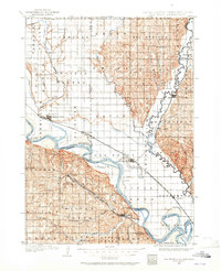
1898 Map of Elk Point
USGS Topo · Published 1965About this map
The Missouri River and Big Sioux River converge at the tristate border of South Dakota, Nebraska, and Iowa in this late 19th-century survey. The landscape is defined by the sharp contrast between the floodplain of the Civil Bend and the surrounding uplands. Major transport networks of the era are clearly visible, including the Chicago Milwaukee and St. Paul R.R. and the Vermilion Ferry, which facilitated movement across the shifting river channels. The map records several early prairie settlements such as Elk Point, Vermillion, and Burbank, alongside more isolated outposts like Lodi and Alsen. Local landmarks like Spirit Mound stand out against the surveyed townships, while the presence of Lake Goodenough indicates the oxbow hydrology of the Big Sioux bottomlands before modern drainage and channelization significantly altered the valley floors.
Find a feature on this map
70 named features on this map. Tap any name to fly to it.
Don’t see what you’re looking for? This feature index may not catch every label — zoom into the map to look around manually.
Map Details
Editions of this 1898 Elk Point Map
2 editions found
Other maps of this area

1897 · Canton
USGS Topo · 1:125,000

1898 · Parker
USGS Topo · 1:125,000

1898 · Elk Point
USGS Topo · 1:125,000

1900 · Canton
USGS Topo · 1:125,000

1901 · Elk Point
USGS Topo · 1:125,000

1907 · Elk Point
USGS Topo · 1:125,000

1955 · Sioux City
USGS Topo · 1:250,000

1955 · Sioux Falls
USGS Topo · 1:250,000

1958 · Sioux City
USGS Topo · 1:250,000

1958 · Sioux Falls
USGS Topo · 1:250,000