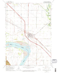
1963 Map of Elk Point
USGS Topo · Published 1970About this map
Elk Point serves as the focal point of this 1963 survey, situated at a critical juncture where the Chicago Milwaukee St Paul and Pacific railroad tracks and the newly developed Interstate 29 corridor intersect. The landscape is defined by its proximity to major water systems, including the wide Missouri River which forms the border with Nebraska, and the winding Big Sioux River to the east.
Find a feature on this map
24 named features on this map. Tap any name to fly to it.
Don’t see what you’re looking for? This feature index may not catch every label — zoom into the map to look around manually.
Map Details
Editions of this 1963 Elk Point Map
3 editions found
Other maps of this area

1898 · Elk Point
USGS Topo · 1:125,000

1901 · Elk Point
USGS Topo · 1:125,000

1907 · Elk Point
USGS Topo · 1:125,000

1955 · Sioux City
USGS Topo · 1:250,000

1958 · Sioux City
USGS Topo · 1:250,000

1959 · Sioux City
USGS Topo · 1:250,000

1963 · Elk Point
USGS Topo · 1:24,000

1963 · Elk Point NE
USGS Topo · 1:24,000

1963 · Jefferson
USGS Topo · 1:24,000

1964 · Burbank
USGS Topo · 1:24,000