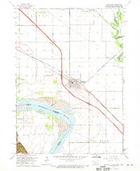
1963 Map of Elk Point
USGS Topo · Published 1970About this map
Elk Point serves as the central hub for this tri-state border region during the early 1960s, where the geography is defined by the sweeping curves of the Missouri River. The town sits at a critical transportation junction, served by the Chicago Milwaukee St Paul and Pacific railroad and surrounded by a landscape divided into named agricultural tracts like Elk Point, Ponca, and Civil Bend.
Find a feature on this map
24 named features on this map. Tap any name to fly to it.
Don’t see what you’re looking for? This feature index may not catch every label — zoom into the map to look around manually.
Map Details
Editions of this 1963 Elk Point Map
3 editions found
Other maps of this area

1898 · Elk Point
USGS Topo · 1:125,000

1901 · Elk Point
USGS Topo · 1:125,000

1907 · Elk Point
USGS Topo · 1:125,000

1955 · Sioux City
USGS Topo · 1:250,000

1958 · Sioux City
USGS Topo · 1:250,000

1959 · Sioux City
USGS Topo · 1:250,000

1963 · Elk Point
USGS Topo · 1:24,000

1963 · Elk Point NE
USGS Topo · 1:24,000

1963 · Jefferson
USGS Topo · 1:24,000

1964 · Burbank
USGS Topo · 1:24,000