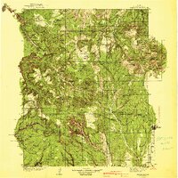
1940 Map of Elk Ridge
USGS Topo · Published 1940About this map
Blanding serves as the primary outpost on the southeastern edge of this high-desert landscape, surveyed in 1935 and published just before the mid-century. The terrain is defined by the deep incisions of the Colorado River at Cataract Canyon and the massive uplift of the Abajo Mountains, including Abajo Peak and Mt Linnaeus. The map reveals a land of cattle ranching and early conservation efforts, shown by the distribution of the Scorup Ranch, Perkins Ranch, and the Kigalia Ranger Sta.
Find a feature on this map
123 named features on this map. Tap any name to fly to it.
Don’t see what you’re looking for? This feature index may not catch every label — zoom into the map to look around manually.
Map Details
Editions of this 1940 Elk Ridge Map
2 editions found
Other maps of this area

1885 · San Rafael
USGS Topo · 1:250,000

1885 · La Sal
USGS Topo · 1:250,000

1886 · Henry Mountains
USGS Topo · 1:250,000

1886 · Abajo
USGS Topo · 1:250,000

1892 · Abajo
USGS Topo · 1:250,000

1892 · Henry Mountains
USGS Topo · 1:250,000

1893 · Abajo
USGS Topo · 1:250,000

1935 · Elk Ridge
USGS Topo · 1:96,000

1940 · Elk Ridge
USGS Topo · 1:125,000

1952 · Mouth of Dark Canyon
USGS Topo · 1:62,500