
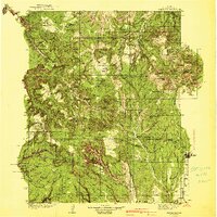
1940 Map of Elk Ridge
USGS Topo · Published 1940About this map
Natural Bridges National Monument dominates the southwestern corner of this survey, highlighting the distinct geological spans of Sipapu Bridge, Kachina Bridge, and Owachomo Bridge. The landscape is a complex network of canyons and high mesas, including the Dark Canyon Plateau and the prominent Abajo Mountains to the east. The area's human history is marked by numerous Cliff Dwelling sites and an Indian Village, alongside more contemporary ranching and forest management outposts. Remote outposts such as the Gooseberry Ranger Sta and Dark Canyon Ranger Sta provided administrative control within the Manti National Forest. To the southeast, the settlement of Blanding represents the primary residential center, while family-held lands like Wilson Ranch, Scorup Ranch, and Perkins Ranch indicate the cattle and sheep operations that defined the local economy during the mid-1930s topographic study.
Find a feature on this map
71 named features on this map. Tap any name to fly to it.
Don’t see what you’re looking for? This feature index may not catch every label — zoom into the map to look around manually.
Map Details
Editions of this 1940 Elk Ridge Map
2 editions found
Other maps of this area

1885 · San Rafael
USGS Topo · 1:250,000

1885 · La Sal
USGS Topo · 1:250,000

1886 · Henry Mountains
USGS Topo · 1:250,000

1886 · Abajo
USGS Topo · 1:250,000

1892 · Abajo
USGS Topo · 1:250,000

1892 · Henry Mountains
USGS Topo · 1:250,000

1893 · Abajo
USGS Topo · 1:250,000

1935 · Elk Ridge
USGS Topo · 1:96,000

1952 · Mouth of Dark Canyon
USGS Topo · 1:62,500

1952 · Natural Bridges
USGS Topo · 1:62,500