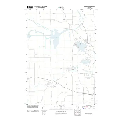
2010 Map of Elkhart Lake
USGS Topo · Published 2010About this map
The Sheboygan Marsh 2 WP 319 Dam and its complex system of agricultural drainage channels, such as Main Ditch and Bergin Ditch, dominate the western half of this Sheboygan County landscape. This drainage network reflects a legacy of transforming wetland into productive acreage, while the eastern portion retains its recreational character centered on Elkhart Lake and Crystal Lake. The village of Glenbeulah sits at a topographic transition point where the Mullet River is impounded by the Glenbeulah Dam, forming Glenbeulah Lake 46. For genealogists, the map preserves the exact locations of several burial grounds, including Saint Paul Cemetery and Saint Fridolin Cemetery near Greenbush. The transition from the marshland to the more elevated, lake-strewn terrain to the east is marked by points like Talmadge Point, illustrating the varied glacial geography of the region.
Find a feature on this map
68 named features on this map. Tap any name to fly to it.
Don’t see what you’re looking for? This feature index may not catch every label — zoom into the map to look around manually.
Map Details
Editions of this 2010 Elkhart Lake Map
This is the sole edition of this map. No revisions or reprints were ever made.
Other maps of this area

1954 · Sheboygan Falls
USGS Topo · 1:62,500

1954 · School Hill
USGS Topo · 1:24,000

1954 · Howards Grove
USGS Topo · 1:62,500

1954 · Franklin
USGS Topo · 1:24,000

1954 · Kiel
USGS Topo · 1:62,500

1954 · Milwaukee
USGS Topo · 1:250,000

1955 · Kewaskum
USGS Topo · 1:62,500

1957 · Madison
USGS Topo · 1:250,000

1958 · Milwaukee
USGS Topo · 1:250,000

1960 · Madison
USGS Topo · 1:250,000