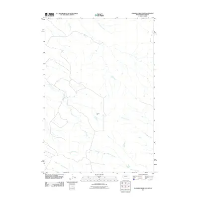
2011 Map of Elkhorn Creek East
USGS Topo · Published 2011About this map
Elkhorn Creek winds through this expanse of Butte County, where the landscape is defined by its drainage systems and water management features. The topography is shaped by several seasonal waterways, including the winding paths of Plum Creek and Beaver Dam Creek in the northern reaches, while Sneezie Dam serves as a critical point of water retention in an otherwise arid region. These drainages converge and diverge across the terrain, reflecting the agricultural and ranching requirements of the western South Dakota plains.
Find a feature on this map
7 named features on this map. Tap any name to fly to it.
Don’t see what you’re looking for? This feature index may not catch every label — zoom into the map to look around manually.
Map Details
Editions of this 2011 Elkhorn Creek East Map
This is the sole edition of this map. No revisions or reprints were ever made.
Other maps of this area

1935 · Harding
USGS Topo · 1:125,000

1954 · Lemmon
USGS Topo · 1:250,000

1954 · Ekalaka
USGS Topo · 1:250,000

1956 · Ekalaka
USGS Topo · 1:250,000

1957 · Lemmon
USGS Topo · 1:250,000

1958 · Ekalaka
USGS Topo · 1:250,000

1965 · Ekalaka
USGS Topo · 1:250,000
1977 · Greasewood Draw
USGS Topo · 1:24,000
1978 · Indian Butte
USGS Topo · 1:24,000
1978 · Gustave
USGS Topo · 1:24,000