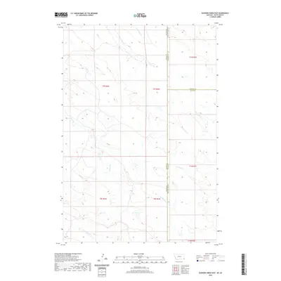
2020 Map of Elkhorn Creek East
USGS Topo · Published 2020About this map
The tri-border region where South Dakota, Montana, and Wyoming converge is defined by a sparse network of seasonal drainages and vast public land divisions. This 2020 study highlights the intricate hydrology of the high plains, centered on the winding course of Elkhorn Cr as it traverses the boundary between Carter and Butte Counties. The map details the convergence of several small tributaries including Frozen Horse Cr and Bean Blossom Cr, which flow through a landscape of sharp relief and high-elevation ridges. The survey captures the intersection of three major state and county lines, providing a precise look at the township and range system that organized this portion of the northern plains. The lack of named settlements reflects the open, unpopulated character of the range along the South Dakota and Montana border.
Find a feature on this map
18 named features on this map. Tap any name to fly to it.
Don’t see what you’re looking for? This feature index may not catch every label — zoom into the map to look around manually.
Map Details
Editions of this 2020 Elkhorn Creek East Map
This is the sole edition of this map. No revisions or reprints were ever made.
Other maps of this area

1935 · Harding
USGS Topo · 1:125,000

1954 · Lemmon
USGS Topo · 1:250,000

1954 · Ekalaka
USGS Topo · 1:250,000

1956 · Ekalaka
USGS Topo · 1:250,000

1957 · Lemmon
USGS Topo · 1:250,000

1958 · Ekalaka
USGS Topo · 1:250,000

1965 · Ekalaka
USGS Topo · 1:250,000
1977 · Greasewood Draw
USGS Topo · 1:24,000
1978 · Indian Butte
USGS Topo · 1:24,000
1978 · Gustave
USGS Topo · 1:24,000