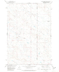
1980 Map of Elkhorn Creek East
USGS Topo · Published 1980About this map
South Beaver Dam Creek and Elkhorn Creek define the drainage patterns of this high-plains landscape where the borders of Montana and South Dakota intersect. This 1980 survey captures a specific tri-county juncture involving Carter, Harding, and Butte counties. The terrain is structured around the Black Hills Meridian, with numerous small watercourses like Frozen Horse Creek and Bean Blossom Creek carving through the prairie. The map provides a precise record of late-20th-century land divisions and the hydrological network of North Indian Creek before significant modern alterations, offering an essential reference for understanding regional ranching boundaries and geological survey points at this remote western crossroads.
Find a feature on this map
10 named features on this map. Tap any name to fly to it.
Don’t see what you’re looking for? This feature index may not catch every label — zoom into the map to look around manually.
Map Details
Editions of this 1980 Elkhorn Creek East Map
This is the sole edition of this map. No revisions or reprints were ever made.
Other maps of this area

1935 · Harding
USGS Topo · 1:125,000

1954 · Lemmon
USGS Topo · 1:250,000

1954 · Ekalaka
USGS Topo · 1:250,000

1956 · Ekalaka
USGS Topo · 1:250,000

1957 · Lemmon
USGS Topo · 1:250,000

1958 · Ekalaka
USGS Topo · 1:250,000

1965 · Ekalaka
USGS Topo · 1:250,000
1977 · Greasewood Draw
USGS Topo · 1:24,000
1978 · Indian Butte
USGS Topo · 1:24,000
1978 · Gustave
USGS Topo · 1:24,000