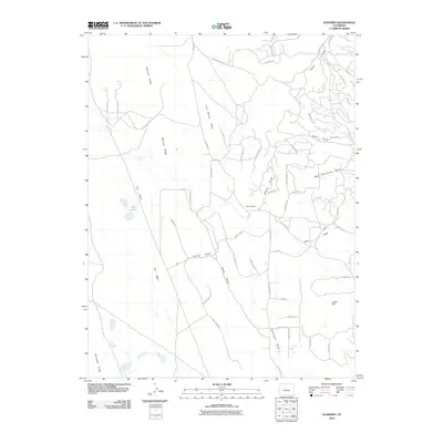
2010 Map of Elkhorn
USGS Topo · Published 2010About this map
Mexican Ridge and Link Spring Ridge define the high ground of this Park County landscape, where the drainage patterns of several significant gulches converge. The Elkhorn Ranch serves as a central point of interest within a network of modern residential roads and older routes like County Rd 17. The hydrologic character of the area is distinct, featuring Association Spring and a series of Playa Lakes situated within a broad topographic depression known as The Basin. This territory is marked by its transition from the high ridges to the deep channels of Garcia Gulch and Sevenmile Gulch. To the southeast, Logan Hill rises above the surrounding valleys, providing a vantage point over the evolving land use and road network that includes Homestead Rd and Vaquero Way.
Find a feature on this map
56 named features on this map. Tap any name to fly to it.
Don’t see what you’re looking for? This feature index may not catch every label — zoom into the map to look around manually.
Map Details
Editions of this 2010 Elkhorn Map
This is the sole edition of this map. No revisions or reprints were ever made.
Other maps of this area

1937 · Como
USGS Topo · 1:62,500

1953 · Denver
USGS Topo · 1:250,000

1956 · Eagle Rock
USGS Topo · 1:24,000

1956 · Elkhorn
USGS Topo · 1:24,000

1956 · Sulphur Mountain
USGS Topo · 1:24,000

1956 · Garo
USGS Topo · 1:24,000

1956 · Fairplay East
USGS Topo · 1:24,000

1956 · Hartsel
USGS Topo · 1:24,000

1957 · Denver
USGS Topo · 1:250,000
1957 · Milligan Lakes
USGS Topo · 1:24,000