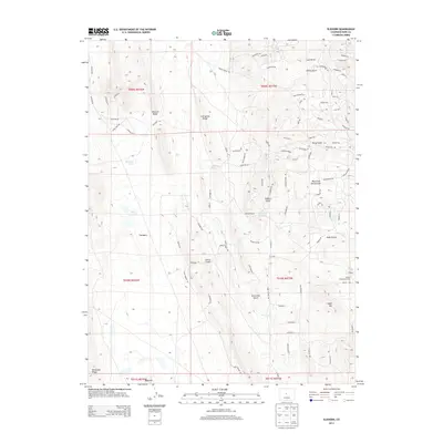
2013 Map of Elkhorn
USGS Topo · Published 2013About this map
Elkhorn and the surrounding high-altitude plains of Park County are defined by a network of drainage gulches and seasonal water sources. The Elkhorn Community House stands as a focal point for the small settlement, which is anchored by the Elkhorn Ranch and supported by numerous vital water points like Elkhorn Spring and Lone Tree Spring. The landscape transitions from the broad expanse of The Basin to prominent elevated features such as Mexican Ridge and Reinecker Ridge. This area shows a distinct pattern of modern rural development, with a grid of named residential roads like Goshawk Rd and Vista Grande Dr intersecting the older ranching terrain. The presence of Playa Lakes and named ephemeral drainages such as Sevenmile Gulch and Garcia Gulch illustrates the delicate water management required in this arid Colorado environment.
Find a feature on this map
98 named features on this map. Tap any name to fly to it.
Don’t see what you’re looking for? This feature index may not catch every label — zoom into the map to look around manually.
Map Details
Editions of this 2013 Elkhorn Map
This is the sole edition of this map. No revisions or reprints were ever made.
Other maps of this area

1937 · Como
USGS Topo · 1:62,500

1953 · Denver
USGS Topo · 1:250,000

1956 · Eagle Rock
USGS Topo · 1:24,000

1956 · Elkhorn
USGS Topo · 1:24,000

1956 · Sulphur Mountain
USGS Topo · 1:24,000

1956 · Garo
USGS Topo · 1:24,000

1956 · Fairplay East
USGS Topo · 1:24,000

1956 · Hartsel
USGS Topo · 1:24,000

1957 · Denver
USGS Topo · 1:250,000
1957 · Milligan Lakes
USGS Topo · 1:24,000