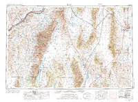
1955 Map of Elko
USGS Topo · Published 1974About this map
Humboldt River corridor serves as the primary artery for settlement and transport across this High Desert landscape, where the Southern Pacific and Western Pacific railroads trace the valley floors. The transition from the ranching hub at Elko to the high peaks of the Ruby Mountains illustrates the regional dependence on water sources like Huntington Creek and Lamoille Creek. Historically significant sites such as the South Fork Indian Res and the Elko Colony appear alongside specialized land uses including the Ruby Lake National Wildlife Refuge. Further east, the terrain opens into vast basins like the Goshute Valley, leading toward the military presence at Wendover AF Aux on the Utah border. This survey captures a mid-century infrastructure network of post offices and rail stops at Halleck, Jiggs, and Shatter before modern interstate development altered the character of these historic ranching valleys.
Find a feature on this map
69 named features on this map. Tap any name to fly to it.
Don’t see what you’re looking for? This feature index may not catch every label — zoom into the map to look around manually.
Map Details
Editions of this 1955 Elko Map
3 editions found

Other maps of this area

1908 · Fish Springs
USGS Topo · 1:250,000

1910 · Fish Springs
USGS Topo · 1:250,000

1925 · Gold Hill
USGS Topo · 1:62,500

1926 · Roberts Mountains
USGS Topo · 1:250,000

1928 · Gold Hill
USGS Topo · 1:62,500

1929 · Roberts Mountains
USGS Topo · 1:250,000

1934 · Jiggs
USGS Topo · 1:125,000

1935 · Halleck
USGS Topo · 1:125,000

1937 · Mineral Hill
USGS Topo · 1:48,000

1937 · Jiggs
USGS Topo · 1:125,000