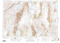
1955 Map of Elko
USGS Topo · Published 1974About this map
The Humboldt River and its major tributaries, such as the North Fork and Marys River, define the settlement patterns of this Nevada landscape. This mid-century revision captures the region during a period of shifting infrastructure, showing the Wendover AF Aux as a decommissioned military facility and the Nevada Northern railroad cutting through Steptoe Valley. Large swaths of the territory are designated as federal and tribal lands, including the Humboldt National Forest and the South Fork Indian Res. Genealogists can trace small ranching hubs and siding stops like Halleck and Tobar, while the extensive Laramie Trail provides a window into historical overland transit routes. The presence of Ruby Lake National Wildlife Refuge marks a significant wetland environment amidst the high desert basins and the prominent Ruby Mountains.
Find a feature on this map
71 named features on this map. Tap any name to fly to it.
Don’t see what you’re looking for? This feature index may not catch every label — zoom into the map to look around manually.
Map Details
Editions of this 1955 Elko Map
3 editions found

Other maps of this area

1908 · Fish Springs
USGS Topo · 1:250,000

1910 · Fish Springs
USGS Topo · 1:250,000

1925 · Gold Hill
USGS Topo · 1:62,500

1926 · Roberts Mountains
USGS Topo · 1:250,000

1928 · Gold Hill
USGS Topo · 1:62,500

1929 · Roberts Mountains
USGS Topo · 1:250,000

1934 · Jiggs
USGS Topo · 1:125,000

1935 · Halleck
USGS Topo · 1:125,000

1937 · Mineral Hill
USGS Topo · 1:48,000

1937 · Jiggs
USGS Topo · 1:125,000