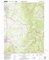
1997 Map of Elkton East
USGS Topo · Published 1999About this map
The S Fk Shenandoah River winds through the western edge of this landscape, anchoring a corridor of historical development that transitions from the river valley into the foothills of the Blue Ridge. This 1990s update, based on 1960s topography, reveals the settled character of communities like Elkton and Shenandoah, where industry and local landmarks like the Norfolk and Western railroad define the local geography. Significant local water sources such as Bear Lithia Spring and Elkton Spring are noted alongside numerous country churches, including Mt Lebanon Ch and Oak Grove Ch.
Find a feature on this map
70 named features on this map. Tap any name to fly to it.
Don’t see what you’re looking for? This feature index may not catch every label — zoom into the map to look around manually.
Map Details
Editions of this 1997 Elkton East Map
This is the sole edition of this map. No revisions or reprints were ever made.
Other maps of this area

1892 · Woodstock
USGS Topo · 1:125,000

1892 · Gordonsville
USGS Topo · 1:125,000

1892 · Harrisonburg
USGS Topo · 1:125,000

1893 · Luray
USGS Topo · 1:125,000

1905 · Luray
USGS Topo · 1:125,000

1929 · Stony Man
USGS Topo · 1:48,000

1930 · Madison
USGS Topo · 1:48,000

1933 · Stony Man
USGS Topo · 1:62,500

1933 · Madison
USGS Topo · 1:62,500

1937 · Elkton
USGS Topo · 1:62,500