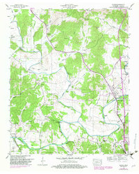
1948 Map of Elkton
USGS Topo · Published 1982About this map
Elk River winds through the southern landscape of Giles County, serving as a geographic anchor for the riverfront town of Elkton and the smaller settlement of Dickson Town. This 1948 survey, based on 1944 aerial photography, illustrates a rural economy transitioning through the mid-20th century, with the Bee Line Highway and the Louisville And Nashville railroad providing vital transit links. The map is a significant resource for genealogists, documenting numerous family-named burial grounds like Trotter Cem, Nelson Cem, and Dunnavant Cem. Small community hubs are scattered across the terrain, including Conway with its local Conway Sch and Aspen Hill to the northwest. Industry is represented by the historical Vinta Mill and Morrell Mill, while the Alabama State Line defines the southern boundary near the growing community of Ardmore.
Find a feature on this map
74 named features on this map. Tap any name to fly to it.
Don’t see what you’re looking for? This feature index may not catch every label — zoom into the map to look around manually.
Map Details
Editions of this 1948 Elkton Map
This is the sole edition of this map. No revisions or reprints were ever made.
Other maps of this area

1888 · Huntsville
USGS Topo · 1:125,000

1892 · Huntsville
USGS Topo · 1:125,000

1936 · Aspen Hill
USGS Topo · 1:24,000

1936 · Elkmont
USGS Topo · 1:24,000

1936 · Ardmore
USGS Topo · 1:24,000

1936 · Pulaski
USGS Topo · 1:24,000

1936 · Tarpley
USGS Topo · 1:24,000

1936 · Elkton
USGS Topo · 1:24,000

1936 · Frankewing
USGS Topo · 1:24,000

1936 · Dellrose
USGS Topo · 1:24,000