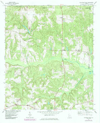
1971 Map of Ellaville North
USGS Topo · Published 1985About this map
The agricultural and forested landscape of Schley County, Georgia, is defined by its numerous small creeks and early 1970s rural settlements. The southern edge of the map features the northern extent of Ellaville, while the rest of the sheet shows a network of crossroads and family-named landmarks. The Central of Georgia railroad cuts across the lower terrain, passing through Walls Crossing as it moves westward. Many of the community hubs center around rural churches like Hopewell Ch and Philippi Ch, alongside legacy commerce sites such as Sellars Store.
Find a feature on this map
24 named features on this map. Tap any name to fly to it.
Don’t see what you’re looking for? This feature index may not catch every label — zoom into the map to look around manually.
Map Details
Editions of this 1971 Ellaville North Map
2 editions found
Other maps of this area

1955 · Phenix City
USGS Topo · 1:250,000

1957 · Phenix City
USGS Topo · 1:250,000

1958 · Phenix City
USGS Topo · 1:250,000

1971 · Rupert
USGS Topo · 1:24,000

1971 · Ideal South
USGS Topo · 1:24,000

1971 · Ideal North
USGS Topo · 1:24,000

1971 · Ellaville North
USGS Topo · 1:24,000

1971 · Tazewell South
USGS Topo · 1:24,000
1971 · Tazewell North
USGS Topo · 1:24,000

1972 · Ellaville South
USGS Topo · 1:24,000