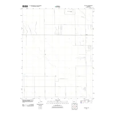
2010 Map of Ellicott
USGS Topo · Published 2010About this map
The settlement of Ellicott serves as the focal point of this high plains landscape east of the Rockies. Characterized by a sprawling grid of rural roads and large ranching properties, the area is defined by the ephemeral path of Black Squirrel Creek and the presence of the Colorado Springs East Airport. Long-standing agricultural operations like the Alger Ranch and Book Ranch highlight the region's ranching heritage, while a network of modern residential spurs and named drives like Centennial Mesa Vw and Leona Homestead Vw show the gradual diversification of land use. Transportation is anchored by State Route 94, which intersects with arterial routes such as N Peyton Hwy and N Ellicott Hwy, connecting these remote homesteads and prairie developments to the broader El Paso County corridor.
Find a feature on this map
39 named features on this map. Tap any name to fly to it.
Don’t see what you’re looking for? This feature index may not catch every label — zoom into the map to look around manually.
Map Details
Editions of this 2010 Ellicott Map
This is the sole edition of this map. No revisions or reprints were ever made.
Other maps of this area

1893 · Big Springs
USGS Topo · 1:125,000

1893 · Colorado Springs
USGS Topo · 1:125,000

1909 · Colorado Springs
USGS Topo · 1:125,000

1942 · Colorado Springs
USGS Topo · 1:125,000

1948 · Falcon
USGS Topo · 1:24,000

1948 · Falcon
USGS Topo · 1:62,500

1949 · Corral Bluffs
USGS Topo · 1:24,000
1950 · Fountain NE
USGS Topo · 1:24,000
1951 · Falcon
USGS Topo · 1:62,500
1951 · Fountain
USGS Topo · 1:62,500