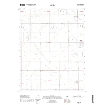
2019 Map of Ellicott
USGS Topo · Published 2019About this map
Ellicott serves as the primary hub for this high plains landscape east of Colorado Springs during the late 2010s. The region is defined by a grid of rural roads and homestead access ways, including Ellicott Hwy and Peyton Hwy, which provide structure to the vast ranchlands and residential pockets. Aviation plays a significant role in the local infrastructure, highlighted by the Colorado Springs East Airport and the specialized Flying View Runway in the northern reaches of the quadrangle. The natural drainage of Black Squirrel Cr cuts a winding path through the center, marking a distinct break in the otherwise orderly section lines. Unique residential naming conventions are evident in clusters such as Silver Bonnet Pt and Fix Run Pt, indicating modern development patterns within this traditional agricultural and ranching corridor.
Find a feature on this map
56 named features on this map. Tap any name to fly to it.
Don’t see what you’re looking for? This feature index may not catch every label — zoom into the map to look around manually.
Map Details
Editions of this 2019 Ellicott Map
This is the sole edition of this map. No revisions or reprints were ever made.
Other maps of this area

1893 · Big Springs
USGS Topo · 1:125,000

1893 · Colorado Springs
USGS Topo · 1:125,000

1909 · Colorado Springs
USGS Topo · 1:125,000

1942 · Colorado Springs
USGS Topo · 1:125,000

1948 · Falcon
USGS Topo · 1:24,000

1948 · Falcon
USGS Topo · 1:62,500

1949 · Corral Bluffs
USGS Topo · 1:24,000
1950 · Fountain NE
USGS Topo · 1:24,000
1951 · Falcon
USGS Topo · 1:62,500
1951 · Fountain
USGS Topo · 1:62,500