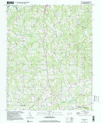
1997 Map of Ellisboro
USGS Topo · Published 2000About this map
Hogans Creek and Jacobs Creek carve through the landscape of southern Rockingham County, leading north toward the Dan River. This area is characterized by a high density of rural religious centers that anchored local life in the late twentieth century, including Ellisboro Ch and Sardis Ch. The settlement of Ellisboro serves as a central point, while the smaller community of Intelligence sits to the northeast. Cultural landmarks such as a Drive-In Theater and numerous family or community burying grounds like Woodland Cem reflect the social fabric of the Piedmont region. Near the southern border, the Rockingham and Guilford County line meets Troublesome Creek, where several pipelines intersect the rural terrain, marking the intersection of traditional agricultural land with modern infrastructure.
Find a feature on this map
32 named features on this map. Tap any name to fly to it.
Don’t see what you’re looking for? This feature index may not catch every label — zoom into the map to look around manually.
Map Details
Editions of this 1997 Ellisboro Map
This is the sole edition of this map. No revisions or reprints were ever made.
Other maps of this area

1951 · Lake Brandt
USGS Topo · 1:24,000

1953 · Winston-Salem
USGS Topo · 1:250,000

1953 · Greensboro
USGS Topo · 1:250,000

1954 · Greensboro
USGS Topo · 1:250,000

1955 · Winston-Salem
USGS Topo · 1:250,000

1962 · Winston-Salem
USGS Topo · 1:250,000

1962 · Greensboro
USGS Topo · 1:250,000

1966 · Greensboro
USGS Topo · 1:250,000

1969 · Summerfield
USGS Topo · 1:24,000

1969 · Belews Creek
USGS Topo · 1:24,000