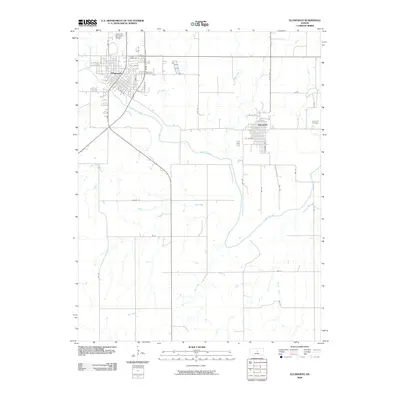
2009 Map of Ellsworth
USGS Topo · Published 2009About this map
Ellsworth serves as the regional hub in this 2009 survey, situated at the confluence of several local drainages and the Smoky Hill River. The map details the grid of the city, including its northern expansion toward the Ellsworth Municipal Airport and the transition from urban streets like Es Main St to the sprawling county road system. Just to the east, the neighboring town of Kanopolis is visible, linked by the river valley and a network of arterial routes such as State Hwy 111.
Find a feature on this map
44 named features on this map. Tap any name to fly to it.
Don’t see what you’re looking for? This feature index may not catch every label — zoom into the map to look around manually.
Map Details
Editions of this 2009 Ellsworth Map
This is the sole edition of this map. No revisions or reprints were ever made.
Other maps of this area

1894 · Ellsworth
USGS Topo · 1:125,000

1955 · Great Bend
USGS Topo · 1:250,000

1957 · Great Bend
USGS Topo · 1:250,000

1957 · Ellsworth
USGS Topo · 1:24,000

1957 · Westfall SW
USGS Topo · 1:24,000

1957 · Westfall SE
USGS Topo · 1:24,000
1957 · Carneiro
USGS Topo · 1:24,000

1957 · Holyrood NE
USGS Topo · 1:24,000

1957 · Black Wolf
USGS Topo · 1:24,000

1958 · Great Bend
USGS Topo · 1:250,000