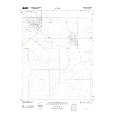
2012 Map of Ellsworth
USGS Topo · Published 2012About this map
The Smoky Hill River meanders across this Central Kansas landscape, carving a wide valley between the historic cattle town of Ellsworth and the neighboring community of Kanopolis. This 2012 survey illustrates the modern layout of these historic settlements, showing how the municipal boundaries and residential grids have matured over a century of development. Local history is anchored at sites like Ellsworth Memorial Cem and Kanopolis Cem, while recreational and economic hubs are represented by the Ellsworth Municipal Airport, Ellsworth Golf Course, and the Kan Western Riders Rodeo Arena. Numerous tributaries, including Oak Cr, Oxide Cr, and Mud Cr, create a complex drainage network that defines the rural parcels surrounding the urban centers. The detailed street grids of Ellsworth are meticulously preserved, showing everything from W N Main St to the outlying Avenue JJ, reflecting the town's enduring role as a regional center.
Find a feature on this map
66 named features on this map. Tap any name to fly to it.
Don’t see what you’re looking for? This feature index may not catch every label — zoom into the map to look around manually.
Map Details
Editions of this 2012 Ellsworth Map
This is the sole edition of this map. No revisions or reprints were ever made.
Other maps of this area

1894 · Ellsworth
USGS Topo · 1:125,000

1955 · Great Bend
USGS Topo · 1:250,000

1957 · Great Bend
USGS Topo · 1:250,000

1957 · Ellsworth
USGS Topo · 1:24,000

1957 · Westfall SW
USGS Topo · 1:24,000

1957 · Westfall SE
USGS Topo · 1:24,000
1957 · Carneiro
USGS Topo · 1:24,000

1957 · Holyrood NE
USGS Topo · 1:24,000

1957 · Black Wolf
USGS Topo · 1:24,000

1958 · Great Bend
USGS Topo · 1:250,000