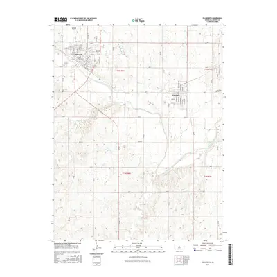
2015 Map of Ellsworth
USGS Topo · Published 2015About this map
The Smoky Hill River meanders across this central Kansas landscape, serving as the primary geographical anchor for the neighboring towns of Ellsworth and Kanopolis. This survey reflects the modern infrastructure of Ellsworth County, including the Ellsworth Municipal Airport and the grid systems of residential streets like Prospect St and E Main St. Local history is preserved through the mapping of several burial grounds, including the Ellsworth Memorial Cem and Kanopolis Cem. The drainage network is particularly well-defined, showing how tributaries like Oak Cr, Mud Cr, and Skunk Cr feed into the river valley. The inclusion of Old Hwy 40 marks the legacy of transcontinental travel through the region, while the meticulous section lines of T15S and T16S illustrate the enduring influence of the Public Land Survey System on the Kansas prairie.
Find a feature on this map
77 named features on this map. Tap any name to fly to it.
Don’t see what you’re looking for? This feature index may not catch every label — zoom into the map to look around manually.
Map Details
Editions of this 2015 Ellsworth Map
This is the sole edition of this map. No revisions or reprints were ever made.
Other maps of this area

1894 · Ellsworth
USGS Topo · 1:125,000

1955 · Great Bend
USGS Topo · 1:250,000

1957 · Great Bend
USGS Topo · 1:250,000

1957 · Ellsworth
USGS Topo · 1:24,000

1957 · Westfall SW
USGS Topo · 1:24,000

1957 · Westfall SE
USGS Topo · 1:24,000
1957 · Carneiro
USGS Topo · 1:24,000

1957 · Holyrood NE
USGS Topo · 1:24,000

1957 · Black Wolf
USGS Topo · 1:24,000

1958 · Great Bend
USGS Topo · 1:250,000