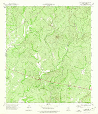
1974 Map of Elm Mountain
USGS Topo · Published 1976About this map
Elm Mountain dominates this portion of Kinney County, rising above a landscape defined by the drainage of Elm Creek. Surveyed in the mid-1970s, the terrain reveals a sparse, rural character typical of the Texas Brush Country, where land use is primarily focused on ranching and resource extraction. The presence of several Gravel Pits suggests the local importance of aggregate mining for road construction and regional infrastructure during this era. A small Roadside Park serves as one of the few designated public landmarks in this expansive territory, positioned along a primary roadway that cuts through the undulating topography. This map is a clear record of the physical geography and limited development in Southwest Texas before modern shifts in land management and infrastructure.
Find a feature on this map
4 named features on this map. Tap any name to fly to it.
Don’t see what you’re looking for? This feature index may not catch every label — zoom into the map to look around manually.
Map Details
Editions of this 1974 Elm Mountain Map
This is the sole edition of this map. No revisions or reprints were ever made.
Other maps of this area

1896 · Brackett
USGS Topo · 1:125,000

1897 · Brackett
USGS Topo · 1:125,000

1938 · Turkey Mountain
USGS Topo · 1:48,000

1943 · Turkey Mountain
USGS Topo · 1:62,500

1944 · Spofford
USGS Topo · 1:62,500

1944 · Brackettville
USGS Topo · 1:62,500

1949 · Cline
USGS Topo · 1:62,500

1958 · Del Rio
USGS Topo · 1:250,000

1964 · Del Rio
USGS Topo · 1:250,000
1974 · Turkey Mountain
USGS Topo · 1:24,000