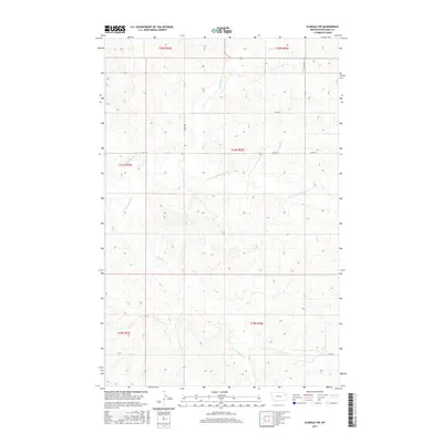
2017 Map of Elmdale SW
USGS Topo · Published 2017About this map
N Fork East Redwater Cr and E Redwater Cr define the drainage patterns across this section of Richland County, where the topography of the Montana plains is segmented by deep coulees and creek beds. This 2017 survey shows a landscape dominated by the Public Land Survey System grid, with section lines and rural routes like Co Rd 134 and Co Rd 133 providing the primary infrastructure. The drainage of Horse Cr in the northern reaches further illustrates the erosional character of the terrain. The map is a study in modern rural geography, where land use is dictated by the availability of water along the Redwater tributaries, and the sparse network of county roads connects widely distributed ranchlands and agricultural holdings.
Find a feature on this map
13 named features on this map. Tap any name to fly to it.
Don’t see what you’re looking for? This feature index may not catch every label — zoom into the map to look around manually.
Map Details
Editions of this 2017 Elmdale SW Map
This is the sole edition of this map. No revisions or reprints were ever made.
Other maps of this area

1909 · Glendive
USGS Topo · 1:250,000

1954 · Glendive
USGS Topo · 1:250,000

1957 · Glendive
USGS Topo · 1:250,000

1958 · Glendive
USGS Topo · 1:250,000
1972 · Kuester Lake
USGS Topo · 1:24,000
1972 · Enid
USGS Topo · 1:24,000
1981 · Sidney
USGS Topo · 1:100,000
1983 · Duplisse Creek North
USGS Topo · 1:24,000
1983 · Elmdale
USGS Topo · 1:24,000
1983 · Carda Coulee
USGS Topo · 1:24,000