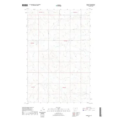
2020 Map of Elmdale SW
USGS Topo · Published 2020About this map
The high plains of Richland County are defined by a network of seasonal drainage and prairie coulees in this 2020 landscape. The hydrologic heart of the area is formed by the convergence of the E Redwater Cr and its northern tributary, the N Fork E Redwater Cr. These winding watercourses carve subtle valleys through the open terrain, creating a pattern of natural corridors that dictate the movement of both water and wildlife across the Montana shortgrass prairie. In the northern reaches, Horse Cr cuts through the sections before joining larger systems beyond the map's boundary.
Find a feature on this map
13 named features on this map. Tap any name to fly to it.
Don’t see what you’re looking for? This feature index may not catch every label — zoom into the map to look around manually.
Map Details
Editions of this 2020 Elmdale SW Map
This is the sole edition of this map. No revisions or reprints were ever made.
Other maps of this area

1909 · Glendive
USGS Topo · 1:250,000

1954 · Glendive
USGS Topo · 1:250,000

1957 · Glendive
USGS Topo · 1:250,000

1958 · Glendive
USGS Topo · 1:250,000
1972 · Kuester Lake
USGS Topo · 1:24,000
1972 · Enid
USGS Topo · 1:24,000
1981 · Sidney
USGS Topo · 1:100,000
1983 · Duplisse Creek North
USGS Topo · 1:24,000
1983 · Elmdale
USGS Topo · 1:24,000
1983 · Carda Coulee
USGS Topo · 1:24,000