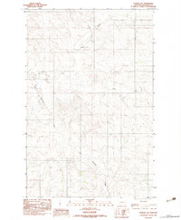
1983 Map of Elmdale SW
USGS Topo · Published 1983About this map
North Fork Redwater Creek and East Fork Redwater Creek carve a complex drainage pattern through this part of Richland County. Published by the U.S. Geological Survey as a provisional map, the document highlights a landscape defined more by its hydrological network than by human settlement. The undulating topography is broken by the significant valley of Horse Creek, which cuts through the northern section of the quadrangle. Aside from the natural watercourses, a notable piece of mid-century infrastructure is the Pipeline that traverses the terrain, indicating the regional industrial activity related to energy transport during the late 1970s and early 1980s. This survey, based on 1976 aerial photography, provides a clear record of the watershed and land contours before more modern developments altered the surface of this Montana prairie.
Find a feature on this map
5 named features on this map. Tap any name to fly to it.
Don’t see what you’re looking for? This feature index may not catch every label — zoom into the map to look around manually.
Map Details
Editions of this 1983 Elmdale SW Map
This is the sole edition of this map. No revisions or reprints were ever made.
Other maps of this area

1909 · Glendive
USGS Topo · 1:250,000

1954 · Glendive
USGS Topo · 1:250,000

1957 · Glendive
USGS Topo · 1:250,000

1958 · Glendive
USGS Topo · 1:250,000

1972 · Kuester Lake
USGS Topo · 1:24,000

1972 · Enid
USGS Topo · 1:24,000

1981 · Sidney
USGS Topo · 1:100,000
1983 · Duplisse Creek North
USGS Topo · 1:24,000
1983 · Elmdale
USGS Topo · 1:24,000
1983 · Carda Coulee
USGS Topo · 1:24,000