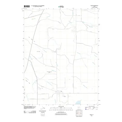
2011 Map of Elmo
USGS Topo · Published 2011About this map
The high desert landscape of Emery County centers on the town of Elmo, where a grid of rural residential streets meets an extensive network of irrigation infrastructure. This arid terrain is defined by its water management, featuring the Carbon Canal and the North Branch Cleveland Canal, which direct resources toward the community and the southern Desert Lake. The Elmo Branch Cleveland Canal serves the agricultural plots near the Elmo Cemetery, illustrating the town's reliance on these man-made waterways to sustain life on the edge of the Poison Spring Bench. To the west, the landscape rises toward Twin Peaks and the Twin Peaks Flat, cut by numerous drainage features such as Marsing Wash and Washboard Wash. The presence of the Intermountain Sprayers Airport suggests the continued importance of aerial support for local ranching or agriculture in this specific pocket of Utah.
Find a feature on this map
42 named features on this map. Tap any name to fly to it.
Don’t see what you’re looking for? This feature index may not catch every label — zoom into the map to look around manually.
Map Details
Editions of this 2011 Elmo Map
This is the sole edition of this map. No revisions or reprints were ever made.
Other maps of this area

1886 · Price River
USGS Topo · 1:250,000

1896 · Price River
USGS Topo · 1:250,000

1914 · Castle Gate
USGS Topo · 1:62,500

1915 · Wellington
USGS Topo · 1:62,500

1916 · Castle Gate
USGS Topo · 1:62,500

1956 · Price
USGS Topo · 1:250,000

1960 · Price
USGS Topo · 1:250,000

1962 · Price
USGS Topo · 1:250,000

1969 · Olsen Reservoir
USGS Topo · 1:24,000

1969 · Elmo
USGS Topo · 1:24,000