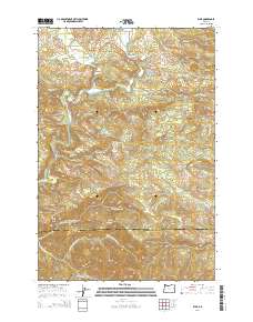
2014 Map of Elsie
USGS Topo · Published 2014About this map
Elsie and the surrounding timberlands of the Northern Oregon Coast Range define this landscape, where the Nehalem River carves a deep valley through the mountains. This survey captures the rural character of Clatsop County, centered on the historic settlements of Mishawaka and Lukarilla. The terrain is marked by high-elevation features like Flat Iron Mtn and the Four Seven Ridge, while the hydrological network includes Spruce Run Lake and Little Falls. A dense web of logging and access roads, such as August Fire Rd and Fish Hawk Falls Hwy, reflects the area's long-standing reliance on forestry. To the north, Sunny Hill-Gem sits near the river bend, providing a specific point of interest for local historians and genealogists tracking the small, often remote communities that developed along the Us-26 corridor.
Find a feature on this map
102 named features on this map. Tap any name to fly to it.
Don’t see what you’re looking for? This feature index may not catch every label — zoom into the map to look around manually.
Map Details
Editions of this 2014 Elsie Map
This is the sole edition of this map. No revisions or reprints were ever made.
Other maps of this area

1937 · Enright
USGS Topo · 1:62,500

1939 · Saddle Mountain
USGS Topo · 1:62,500

1941 · Keasey
USGS Topo · 1:62,500

1941 · Timber
USGS Topo · 1:62,500

1941 · Enright
USGS Topo · 1:62,500

1943 · Keasey
USGS Topo · 1:62,500

1943 · Saddle Mtn.
USGS Topo · 1:62,500

1948 · Vancouver
USGS Topo · 1:250,000

1950 · Vancouver
USGS Topo · 1:250,000

1950 · Vancouver
USGS Topo · 1:250,000