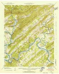
1941 Map of Elverton
USGS Topo · Published 1952About this map
The Cumberland Plateau and the parallel ridges of East Tennessee dominate this 1941 landscape, where the Watts Bar Reservoir is shown filling the valleys of the Emory River and the Clinch River. This Tennessee Valley Authority field examination documents a rural society of small settlements and family farms positioned between steep landforms like Walden Ridge and Blackoak Ridge. The area's transit is defined by the Nashville Highway and the Southern railroad, which served communities such as Elverton and Winslow.
Find a feature on this map
66 named features on this map. Tap any name to fly to it.
Don’t see what you’re looking for? This feature index may not catch every label — zoom into the map to look around manually.
Map Details
Editions of this 1941 Elverton Map
3 editions found
Other maps of this area

1887 · Kingston
USGS Topo · 1:125,000

1891 · Kingston
USGS Topo · 1:125,000

1893 · Briceville
USGS Topo · 1:125,000

1893 · Kingston
USGS Topo · 1:125,000

1895 · Wartburg
USGS Topo · 1:125,000

1895 · Loudon
USGS Topo · 1:125,000

1895 · Briceville
USGS Topo · 1:125,000

1896 · Wartburg
USGS Topo · 1:125,000

1896 · Briceville
USGS Topo · 1:125,000

1935 · Camp Austin
USGS Topo · 1:24,000